Thursday, November 30, 2017

●● Locations

Canals of London ..
Cargo Chokepoints - Ports  
Highgate, Hampstead ..
Lambeth Palace ..
South Downs ..
St Katharine Docks ..
Westminster Palace ..


Europe - modern 

Fantasy 

Global

London 
Military Bases

Oz

Playlists 


USSR, Russia

Kremlin ..

Monday, November 27, 2017

Bembridge Fort

.£2m house for sale complete with a VICTORIAN FORT in its garden - Forces > .

Bembridge Fort (map reference SZ624861) is a fort built on the highest point of Bembridge Down close to the village of Bembridge on the Isle of Wight, England. It is one of the many Palmerston Forts built around Portsmouth during the period of the Second French Empire, as a safeguard against a perceived threat of French invasion by Napoleon III.

The hexagonally shaped fort was the main stronghold for the South East coastline of the Isle of Wight and was designed as a final retreat if the island was to be invaded. Due to its location with a view over both Sandown Bay and the Eastern Solent it acted as the command and control centre for the Western batteries on the Isle of Wight (Redcliff Battery, Yaverland Battery, Sandown Fort and Sandown Barrack Battery). The fort had barrack accommodation for 4 officers and 106 men with an original armament of six RBL 7 inch Armstrong guns mounted on the parapet side.

1920-1939: Territorial army observation post for artillery based at Yaverland Battery.

1938: Royal Navy's anti submarine division laid indicator loops across the channel into Spitbank Fort during the war three further harbour defence loops were laid and monitored from the fort.[5]

1939-1945: Command post for anti-aircraft regiments and H.Q. for local home guard, two Allan Williams turrets were installed. The fort also housed a reserve radar station after the bombing of Ventnor radar station.

Bridges of London

Bridges of London > .
Bridges That Built London > .
Secrets Of Waterloo Bridge >London's Bridges - Lst >> .

London Bridges Timeline - Lst > .
London's Bridges - Lst >> .

London's Canals & Waterways - Lst >> .

Boston, Lincolnshire, WW2

 
~1943 Life in Rural Britain during WW2 (ca.1943) > .

Bradford Exchange Railway Station

1846-7-1 to 1967-10-2 Lost in Time: Bradford Exchange - Ruairidh MacVeigh > .

Brighton

.
High Volkage: Volk's Electric Railway - Jago > .
Brighton - Deadly Victorian Beach Holidays | Hidden History > .
1955 Brighton Story | BFI > .

Brighton

"Brighton could already count 40 000 inhabitants, most of them permanent, at the June census of 1841. But growth on the grand scale began with the railway age, as the railways boosted existing small settlements (they very rarely started new resorts from scratch) by making access cheaper in time and money. The main beneficiaries around mid-century were middle-class families, from the substantial to the struggling, although the relative anonymity of resort settings, especially in southern England, allowed young bachelors in mundane employment to reinvent themselves and go on the spree for a fortnight."

http://www.bbc.co.uk/history/british/victorians/seaside_01.shtml .

The West Pier is a ruined pier in Brighton, England. It was designed by Eugenius Birch and opened in 1866. It was the first pier to be Grade I listed in England and Wales but has become increasingly derelict since its closure to the public in 1975. As of 2022 only a partial metal framework remains.

The pier was constructed during a boom in pleasure pier building in the 1860s, and was designed to attract tourists to Brighton. It was the town's second pier, joining the Royal Suspension Chain Pier that opened in 1823. The West Pier was extended in 1893, and a concert hall was added in 1916. The pier reached its peak attendance at this time, with 2 million visitors between 1918 and 1919. Its popularity began to decline after World War II, and concerts were replaced by a funfair and tearoom. A local company took over ownership of the pier in 1965, but could not meet the increasing costs of maintenance and filed for bankruptcy.

The pier closed to the public in 1975 and fell into disrepair and gradually collapsed. Major sections fell into the sea during storms in late 2002, and two separate fires, both thought to be arson, in March and May 2003 destroyed most of the remaining structure, leading to English Heritage declaring it beyond repair. Some structured demolition took place in 2010 to make way for the i360 observation tower; further structural damage from storms has occurred since.
 -------
"After WWI, Brighton was still a popular holiday destination, and Art Deco landmarks such as the Lidos at Black Rock (1936) and Saltdean (1937), and Shoreham Airport were opened: scheduled passenger flights began to the Isle of Wight, Croydon, Deauville and Jersey. Popular cinema flourished, and Art Deco picture houses were opened across Brighton to huge crowds. Brighton Dome was redesigned in the Art Deco style, and opened as Brighton’s principal concert, conference and entertainment venue in 1935. The state-of-the-art Modernist block of flats at Embassy Court was built in 1936.

But life for many people was not so glamourous. The 1920s also saw Brighton growing in size: in 1921, it was the most densely populated county borough outside London’s West Ham. The first large council estates were built at Moulsecoomb and Queen’s Park in this decade. Whitehawk and Carlton Hill followed in the 1930s, as did mass-unemployment relief projects like the construction of the Black Rock to Rottingdean sea wall, and town centre slum clearances, replacing old fishermen’s cottages with wider streets, larger shops, and flats. The 1930s and ‘40s saw Brighton develop a seedy underworld, peopled by criminal gangs and rife with protection rackets and vice - described in novels like Brighton Rock (Graham Greene, 1938) and Hangover Square (Patrick Hamilton, 1939).

The outbreak of World War II in 1939 saw sections of the Piers removed to prevent enemy landings, while beaches were mined and closed to the public. Fishermen and traders were removed from the seafront. Many local children (and evacuees from elsewhere) were evacuated as Brighton was targeted by regular bombing raids. There were 56 raids in all and over 5,000 houses were damaged or destroyed."

Brookwood War Graves Cemetery


Brookwood Military Cemetery [near Woking, Surrey] is the largest Commonwealth War Graves Commission (CWGC) cemetery in the United Kingdom and is the final resting place for more than 5,000 service personnel from Australia, Canada, India, New Zealand, South Africa and the UK and Ireland. It also contains plots dedicated to other nations such as France, Belgium, Poland and Czechoslovakia. It is also the location of the Brookwood American Cemetery and Memorial.

Bunkers, Underground

Cold War 1
23-11-17 NORAD/Space Force: Inside Cheyenne Mountain - nwyt > . skip > .


From Liverpool to Dover, Westminster to Woolwich there are hidden secrets beneath our feet! Underground hideouts that would hide a secret army - ready to attack if Germany landed troops during WW2 ... the wartime bunker Churchill refused to use in Mort-West London ... London's secret tunnels and secret stations and much more

Sunday, November 26, 2017

Canals of London

Barging Through Old London in 1924 > .
Modern London's Regents Canal - Little Venice to Camden Lock - Joolz > .

Take a trip on a horse-drawn towing barge from Limehouse into old Central London! The trip goes over the Regents Canal from Limehouse, via the Wharves of East London, Mile End Road, Various locks, White Chapel, Heartford Union Canal, Old Ford, Acton's Lock, Hackney, through Islington Tunnel, passes under the New River, over the GNR at Kingscross, under the Midland at St.Pancras, Kentish Town, Alpine Chalet, through Regents Park and London Zoo and ends at Paddington Basin just off Edgeware Road. Viewers have reported that this route can still be followed, either by boat or by following the old paths for the horses to draw the barges through the canal until about 50 years ago. It is remarkable how much of this film can still be recognized today. 00:00 Regents Canal Dock in Limehouse 00:13 The barge is transporting 85 tons of coal 00:33 Wharves of East London 01:00 Under Mile End Road 01:22 Another lock, raising the barge by 6 feet 01:53 Whitechapel 02:16 Heartford Union Canal; River Lee branches off to Bishops Stortford 02:40 Rural scenery at Old Ford 03:10 Acton's Lock by London Fields 03:40 Through Hackney 03:53 Past City Basin 04:20 Through Islington Tunnel, assisted by steam tug, near Angel 04:32 The tunnel is 1.2 km long, takes half an hour 04:45 End of Islington Tunnel 04:58 Over the Great Northern Railway at Kings Cross 05:27 Under the Midland at St.Pancras 05:48 Kentish Town 06:10 Lock keeper's Alpine Chalet 06:20 The 12th lock since leaving Limehouse 06:38 Camden Lock 06:50 Under the old London and Western Main Line 07:00 Primose Hill (Lovey's central) 07:08 Through Regents Park 07:18 Through London Zoo 07:44 Another tunnel without the help of a tug 07:54 Gilbeys Wharf and the old Camden Goods Station 08:18 Hard work without the assistance of Dobbin the horse 08:35 End of the journey at Paddington Basin, near Edgware Road 08:49 The End 

If you want to see what the Regents Canal looks like today, please watch the great Joolz Guides Youtube channel: https://www.youtube.com/watch?v=h_Lp9... .

Chelsea Physic Garden

Chelsea Physic Garden, WW2 - Gresham > .

Chaldon Church St Peter's and St Paul's, Surrey

Chaldon Church St Peter's and St Paul's, Surrey > .


Chaldon
http://www.paintedchurch.org/chaldon.htm .
http://chaldonvillagecouncil.org.uk/ .

Chaldon Church St Peter's and St Paul's, Surrey
https://www.youtube.com/watch?v=Tn6dS0Qx9Pk .
https://www.youtube.com/watch?v=djsIkbv0Xn0 .

Pilgrims Lane, Chaldon
https://www.youtube.com/watch?v=cLTwy9gRctM .

http://www.geograph.org.uk/showmap.php?gridref=TQ33865552 .
http://www.geograph.org.uk/showmap.php?gridref=TQ33765305 .

Chaldon, Caterham

Surrey - 1874 - Chaldon, Caterham
http://mapco.net/surrey1874/surrey28.htm .
Surrey - 1874 - Banstead, Reigate
http://mapco.net/surrey1874/surrey27.htm .
Surrey - 1874
http://mapco.net/surrey1874/surrey1874.htm .

Cheddar Gorge, Mendip Hills, Somerset

.
Cheddar Gorge, Mendip Hills, Somerset
Drone > .     

Crystal Palace - London

.Crystal Palace: An Omen of Things to Come - Mega > .

Wednesday, November 22, 2017

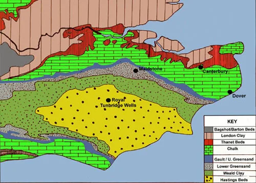
GeK - Geology, Kent

Gloucester & Sharpness, Purton Hulks


The Purton Hulks or Purton Ships' Graveyard is a number of abandoned boats and ships, deliberately beached beside the River Severn near Purton in Gloucestershire, England, to reinforce the river banks. Most were beached in the 1950s and are now in a state of considerable decay. The site forms the largest ship graveyard in mainland Britain.
...
The stretch of canal from Sharpness to Purton runs very close to the river. At a high spring tide they were separated by little more than the width of the towpath. The canal also has no locks, and owing to its width, not even any stop locks. Any damage to the canal bank could thus render the entire canal unnavigable.... 
A riverbank collapse in 1909 led to concerns that the barrier between the river and the Gloucester and Sharpness Canal would be breached. Old vessels were run aground and soon filled with water and silt to create a tidal erosion barrier. The vessels included steel barges, Severn trows and concrete ships. The boats came from throughout the British Isles and were built in the second half of the 19th century and the first half of the 20th.

Since 2000, archaeological investigations have been undertaken to find out more about the vessels and their states of decay. Explanatory labels have been provided. One barge has been scheduled as an ancient monument and several are included in the National Register of Historic Vessels.


Tuesday, November 21, 2017

Hamble - ATA Ferry Pool (No 15)

An ATA Ferry Pool started at Hamble in September 1940, lead by Captain Brian Wardle, and at the beginning it was a sub-pool of No 1 Ferry Pool, but soon it became No 15 Ferry Pool and a year later became an all-women Ferry Pool


Hampstead pit garage - London

1937 - Hampstead > .
Hoisting Appliance Company.

Highgate, Hampstead

Highgate Cemetery, Hampstead Heath - Britannia >> . 

Highgate Cemetery is a place of burial in north London, England. There are approximately 170,000 people buried in around 53,000 graves across the West Cemetery and the East Cemetery at Highgate Cemetery. It is one of the Magnificent Seven cemeteries in London.

The "Magnificent Seven" is an informal term applied to seven large private cemeteries in London. They were established in the 19th century to alleviate overcrowding in existing parish burial grounds. Highgate cemetery in its original form—the northwestern wooded area—opened in 1839, as part of a plan to provide the seven large, modern cemeteries around the outside of central London. The inner-city cemeteries, mostly the graveyards attached to individual churches, had long been unable to cope with the number of burials and were seen as a hazard to health and an undignified way to treat the dead. The initial design was by architect and entrepreneur Stephen Geary. The first burial was Elizabeth Jackson of Little Windmill Street, Soho, on 26 May.

Highgate, like the others of the Magnificent Seven, soon became a fashionable place for burials and was much admired and visited. The Victorian attitude to death and its presentation led to the creation of a wealth of Gothic tombs and buildings. It occupies a spectacular south-facing hillside site slightly downhill from the top of the hill of Highgate itself, next to Waterlow Park. In 1854 the area to the east of the original area across Swains Lane was bought to form the eastern part of the cemetery. Both the cemeteries are still used today for burials, but these areas are closed to the public. Most of the open unforested area in the East Cemetery still has fairly few graves on it.

The cemetery's grounds are full of trees, shrubbery and wildflowers, most of which have been planted and grown without human influence. The grounds are a haven for birds and small animals such as foxes.

Highgate Cemetery is notable both for some of the people interred there as well as for its de facto status as a nature reserve. Karl Marx is buried in the East Cemetery. Highgate Cemetery is designated Grade I on the Register of Historic Parks and Gardens.

History of London

Five Catastrophes That Made London - Gresh > .

A brief introduction to the complicated evolution of the historic city of London. Here, Peter Murray explains the development of the capital, from its inception 2,000 years ago with the Roman settlement on the Thames to its role as a major trading city and establishment of seat of British government, and discusses particular challenges it has faced, including the Great Fire of 1666, the onslaught of the Blitz in World War II, and the expansion of the city.

London Evolution Animation > .


Agas Map of Early Modern London 
Great Fire of London, 1666 

Monday, November 20, 2017

IWM - Imperial War Museum


Founded during WW1 to tell the stories of those whose lives had been touched by the conflict – objects were still being collected for the new Imperial War Museum whilst WW2 raged on.

The Imperial War Museum opened its first 'permanent' exhibition at Crystal Palace on 9 June 1920, after three years of temporary exhibitions and scattered storage.

In October 1939, the decision was made to expand the remit of the museum. Although the outcome of the current conflict was uncertain, the museum would also cover the events of the new war. A skeleton staff was maintained and the Lambeth Road site was used as a timber dump and a Royal Army Ordnance Corps billet. A barrage balloon was tethered in front of the building.

Ernest Blaikley, IWM’s first keeper of art, oversaw the evacuation of key works of art from the Imperial War Museum. The remaining collection proved useful. The library continued to function and the map collection was constantly reviewed. Photographs from WW1 were used for training and propaganda purposes. 

In 1940, after the withdrawal of the British Expeditionary Force (BEF) from Dunkirk created an acute shortage of equipment and weaponry, the museum was asked to help the military by handing over items from its collection. The trustees of the museum agreed to hand over some exhibits – but, because of its significance to the museum, refused to give up the gun manned by Jack Cornwell at the Battle of Jutland.

The Ministry of Works questioned the museum (1940) about failure to evacuate more of its collection. Some additional items were removed to the countryside – but the majority of the collection remained at the museum to face the risk of German bombs.

A short seaplane which had flown at the Battle of Jutland was shattered when a German bomb fell on the Naval Gallery on 31 January 1941. The group of men who had been working in the gallery repairing earlier damage had a narrow escape as they had left for lunch shortly before the bomb landed. This was just one of more than 40 incendiary hits on the building throughout the war.

Although the museum had been reopened briefly in 1940, and held two small exhibitions in 1944 and 1945, it did not officially reopen until 26 November 1946.

sī vīs pācem, parā bellum

igitur quī dēsīderat pācem praeparet bellum    therefore, he who desires peace, let him prepare for war sī vīs pācem, parā bellum if you wan...